

The White House is expected to extend the Jones Act waiver for up to 90 days as early as Friday to help blunt fuel price pressures tied to the Iran conflict, according to two sources familiar with the decision.The move would temporarily ease requirements that goods transported between U.S.

For Capt. Paul C. LaMarre III, the maritime industry isn’t a career choice as much as it is a family inheritance — and, in his words, “all I’ve known my entire life.” In a recent interview with Maritime Reporter TV, Captain LaMarre gives unique insights on the operating efficiently, effectively and safely on the Great Lakes system – the United States’ ‘Fourth Sea’ – and with passion

The U.S. Army Corps of Engineers Civil Works mission began in 1824 when our Nation’s fifth President, James Monroe, signed into law a bill to improve navigation on the Ohio and Mississippi Rivers. While Corps projects have always been large and complex, the Civil Works missions have evolved over time to incorporate new regulations, policies, shifts from political pressures, and unfortunately

The advancement of the recently announced America’s Maritime Action Plan (MAP) is embraced by the ports in the bi-state St. Louis region as a unique opportunity to play a role in this comprehensive federal framework. The MAP is a blueprint for rebuilding the nation’s maritime strength, increasing the use of technology, enhancing supply chain resilience and expanding domestic industrial capacity.
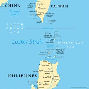
Marilyn Hubalde still remembers the first time she heard the thunderous chop of military helicopters swooping over this northernmost outpost of the Philippines, less than 90 miles from Taiwan. It was April 2023, when Filipino and American troops descended on the cluster of 10 emerald green islands of Batanes province for amphibious warfare drills.